Fort Rock
On our days off we are trying to get out and see as much of Central Oregon as we can while we are here. One place we had never heard of was Fort Rock, and we learned about it from a local travel channel.
 |
| Fort Rock |
Fort Rock is a volcanic landmark called a tuff ring and is actually located where an ice age lake once existed. The ring is about 4,460 feet in diameter and stands about 200 feet high. The age of Fort Rock has been estimated to be between 50,000 - 100,000 years old. It would have been a time when pluvial lakes filled the valleys of central Oregon and much of the Great Basin of the Western USA. At its maximum, the water in Fort Rock lake is estimated to have covered 900 square miles and was about 150 feet deep.


There was/is a town of Fort Rock, named by the towns founder Ray Nash. Fort Rock flourished a bit during the homestead period before world War 1, but today there is little that remains except a small museum consisting of 10 buildings which were part of the town from the mid 1800's through early 1920's. People were drawn to Fort Rock because they could homestead and they thought the railroad would be coming through the town. Plans were drawn, but in the end, the railroad went further south and north, by-passing the little town and securing its fate.


We also visited Fort Rock State Park, a day use area that sits at the base of the formation. There are trails that will take you around the rock for a closer look. Hiked a short way up and into the the bottom of Fort Rock which allowed us a remarkable view of the landscape of the farming area surrounding the Rock.
Ice Caves
 |
| Looking into Ice Cave |
 |
| Ice Cave |
From Fort Rock we headed back towards La Pine, opting for a gravel road instead of the paved road. This allowed us to visit the Ice Caves which turned out to be a lava tube that had deteriorated and become exposed. The temperatures that day were between 95-100 degrees, yet as we neared the opening of the cave, the temps dropped 30-40 degrees, The tubes have collapsed so you can no longer walk any distance in them. Was sure pleasant to stand at the opening for a while.
While this lava tube could not be toured, we discovered later there are tours offered by the US Forest Service out of Bend Oregon where you can take a self guided tour of a mile long tube. Will do another day!
Smith Rock
 |
| Smith Rock, with Crooked River |
Our day at Smith Rock was very different from Fort Rock. Smith Rock has sheer cliffs of tuff and basalt and are ideal for rock climbing. Smith Rock is generally considered the birthplace of modern American sport climbing. You can do sport climbing, traditional climbing, climbing multi-pitch and bouldering. Besides climbing, the park has some great trails to hike, from easy to hard and that was what we were there to do that day.
 |
After 10 minutes of rain, river of
water coming down trail |
But the day was cut short when the dark clouds hanging over the park opened up and started to downpour on us. As we were walking down the trail, a lightning strike hit right overhead, followed immediately by a very large thunder clap, and then a down pour. We raced to a kiosk with an overhang and huddled with about 6 others. As we stood there, we watched as the rain immediately create waterfalls, and saw create a small river as it ran down the path we had just come down. We waited about 20 minutes and the rain seemed to be lessening so we decided to make a run for it back up the path to the car. We were soaked clear through by the time we got to the car, but we were safe. By the time we got home, the clouds had broken, rain had stopped and it turned out to be a great day. We hope to go back and hike the trails, on a very sunny day!
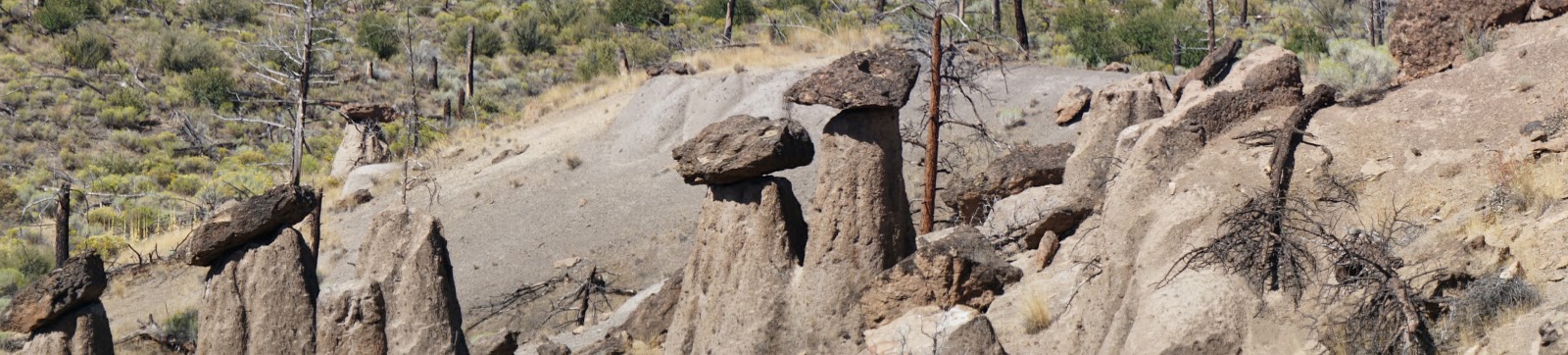
Balanced Rocks
 |
| Hoodoo |
 |
Balanced Rocks and Metolious
River |
At the other end of the lake from our campground, is Balanced Rocks, or more formally known as Hoodoo's. They are remnants of multiple lava flows, where the rock on top was a later flow that was compressed and is actually harder than the rock it is sitting on. As the dirt in the area erodes, and wind and weather erode the shape of the rocks, we are left with Balanced Rocks.
 |
| Human made Hoodoo's |
This little area, overlooks the arm of the Metolious River that enters into Lake Billy Chinook. The short trail that overlooks the rocks, is lined by balanced rocks other visitors have created.
We are always amazed at the things you can find and experience in any area we visit. There are the commercial tourist attractions to see, but the little dirt road can take you some amazing places.
Love taking the road less traveled.