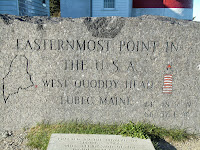
Upon leaving Connecticut, our goal was to head a little further east to visit Acadia National Park in Bar Harbor, and also to reach another milestone in our travels. Within the United States, we have visited the Lowest point, been on Mt. Whitney, the highest point, visited the Southern and Western most points and now the Eastern most point in the contiguous states was our destination. West Quoddy Head Maine is that Eastern most point. That is not a misprint. West Quoddy is the Eastern most point.
 |
| view from Bar Harbor |
 |
| Bar Harbor |
Before we went to West Quoddy, we spent a couple of days in and around Bar Harbor. A true accent pronounces it 'Baa Haabor'. The beautiful little town of Bar Harbor is full of shops and restaurants, of course, all selling lobster on their menus. It is also a stop for cruise lines, and there were three in port the day we were there. The views from town of the Atlantic Ocean and the many islands just off shore, reminded us of the San Juan Islands off Seattle Washington. Bar Harbor got its name due to a sand bar that stretches from the town to Bar Island. You must be aware of the tides tables, because at low tide the sand bar is wide enough to drive a car across. But at high tide, the bar is underwater and you will have to wait 8 hours to get back. They say no one will come and get you!
 |
| View from Cadillac Mt. |


Because Acadia National park is located on an island, the coast line is rugged and beautiful. A highlight of the park is Cadillac Mountain, where, because of it's elevation of 1528', you can be the first to see the sunrise in the USA. Sadly, we did not make it to view either a sunrise or a sunset!
We opted for a guided tour of Acadia National Park's 27 miles of loop road which comprises much of Mount Desert Island. The park was originally created as Lafayette National Park in 1919, it's the oldest National Park east of the Mississippi River, and was renamed Acadia in 1929. Acadia has 120 miles of hiking trails throughout the park and thanks to John D. Rockefeller Jr. there are over 50 miles of gravel carriage trails that can also be hiked. http://en.wikipedia.org/wiki/Acadia_National_Park
 |
| Popovers, homemade butter and jam |
 |
| Lunch on the lawn, looking at Jordan Pond |
http://www.jordanpond.com/history.html
 |
| Jordan Pond |
Another day, we participated in a local towns Autumn Days Chowder competition. Six local restaurants competed. We tasted everything from good 'ole clam chowder to sea food chowder to the one that we thought best, scallop/bacon chowder!

 With our bellies full, we headed to see the Penobscot Bridge and Fort Knox. Fort Knox in Maine is named for the first US Secretary of War, the same man Fort Knox in Kentucky is named. The fort in Maine spent 25 years being built from 1844-1869, was never completed and never occupied. When it was decommissioned, the name was then given to the fort in Kentucky.
 |
| From the top of the observatory |
 The Penobscot Bridge is home to the Penobscot Narrows Observatory, the first bridge observation tower in the United States and the tallest public bridge observatory in the world. The tower reaches 420 feet into the air.
Last day in Maine, we headed further east to see and touch the furthest point east in the United States, Lubec Maine and West Quoddy Head Lighthouse.


 Day started with a tour of The Bay of Fundy in a lobster boat from Lubec, Maine. Lubec has the distinction of being known as the Eastern most town. This part of Maine has several unique geographical features, Machias Seal Island and North Rock. Both sit off the easternmost point and are claimed by both the U.S. and Canada and their sovereignty is still in dispute. Also in this easternmost area is the Old Sow, the largest tidal whirlpool in the Western Hemisphere. Our captain sailed to the area where the Old Sow was suppose to be, but apparently the tides and currents were not going to show her to us.
 |
| East Quoddy Head Light House |
 |
| Minke Whale |
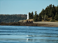
Our boat took us past East Quoddy Head light house, many beautiful private islands, and along the way we spotted eagles, harbor seals, whales and porpoises. It was a unseasonably warm fall day, and the sea was calm and the fall colors bright.
This part of Maine is known as “Down East“, because it lies in the Southeast corner of the state. Maine is a strange state, as it is about the same size as the other 5 NE states put together. But the total population of the entire state is only a little over 1,300,000 people.
Once back on land and just outside Lubec, we crossed over the Canadian
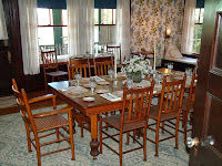
 border into Nova Scotia and onto and island called Campobello and home to FDR’s family summer cottage. It surprised us too, Campobello is in Canada. Through the efforts of both Canadian and US Governments, the home and grounds are operated as the only International Park in the world. The home remains furnished as it was when FDR’s family occupied it.
  |
| Roosevelt's Summer Cottage |
 |
| Roosevelt's dining room |
 |
| West Quoddy Head Light House |
 |
| Marker at the lighthouse |
 |
| View from the trail |

 |
| Blueberry Cobbler |
 |
| Stuffed Lobster |
Fall Foliage, Maine to New York


